Smart Road Monitoring Connected Vehicle
i-Probe's Smart Road Monitoring Connected Vehicle (SRMCV) provides road management agencies a user-friendly, easily-deployable tool for road condition monitoring. It is designed to provide agencies with fast and more frequent data collection capability and rapid output turnaround time compared to traditional methods and without the constraints of outsourcing services.
How it works
The SRMCV is a regular car (Connected Vehicle) which transmits onboard sensor data to a secure server. Data includes driving data (e.g., steering wheel control), movement data (e.g., geolocation), or vehicle condition (e.g., tire pressure). The data from these onboard sensors can also be used to detect environmental conditions.
The onboard accelerometer senses the horizontal and vertical movement that a car experiences when it hits a bump or drives over rough roads.
This road roughness data (ride quality), coupled with geolocation and speed, can be used to effectively map the roughness anywhere the vehicle travels. The SRMCV is equipped with a high-resolution dashboard camera integrated into the monitoring system allowing it to log video or photos that are geolocated and transmitted with the road condition data in near real-time.
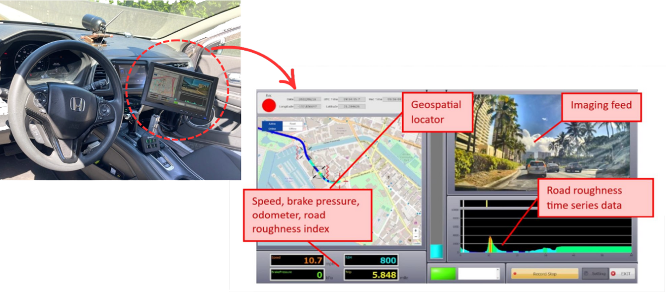
In-Vehicle Equipment
Work Process
1
Data Collection
2
Analysis
3
Mapping
SRMCV
Near real-time monitoring with a custom Connected Vehicle.

Automated pavement distress identification and classification with video verification.
Delivers custom pavement condition mapping with superior turnaround time.
Technology - SRMCV Benefit

Simple
No specialized license or training necessary to operate a regular car or onboard systems.

Consistent
Provides consistency over entire data set (no subjectivity due to different inspectors).

Flexible
The SRMCV is provided on a subscription basis and housed by the road agency to be used at their convenience. Unlike with outsourcing services, the road agency has full control over scheduling use and resource allocation.

High Speed
RoCoMo-BDAS machine-based detection and algorithms eliminate human subjectivity and error, improving data integrity. RoCoMo-BDAS enables you to gain insight through trends in consistent datasets.

Fast Turnaround
Output turnaround is significantly faster than traditional methods, ranging from real-time to a few days depending on level of service and volume.

Machine Detection & Precision
Machine-based detection eliminates human bias, omissions, and errors often associated with manual inspections. Detects almost imperceptible distresses at high speed.
Technology - SRMCV Benefit
Simple
No specialized license or training necessary to operate a regular car or onboard systems.
Consistent
Provides consistency over entire data set (no subjectivity due to different inspectors).
Flexible
The SRMCV is provided on a subscription basis and housed by the road agency to be used at their convenience. Unlike with outsourcing services, the road agency has full control over scheduling use and resource allocation.
High Speed
RoCoMo-BDAS machine-based detection and algorithms eliminate human subjectivity and error, improving data integrity. RoCoMo-BDAS enables you to gain insight through trends in consistent datasets.
Fast Turnaround
Output turnaround is significantly faster than traditional methods, ranging from real-time to a few days depending on level of service and volume.
Machine Detection & Precision
Machine-based detection eliminates human bias, omissions, and errors often associated with manual inspections. Detects almost imperceptible distresses at high speed.
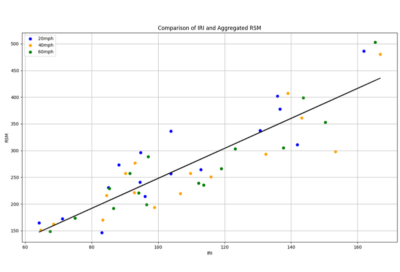
Correlation with IRI
i-Probe systems measure road roughness with an index called Road Surface Monitoring (RSM). In controlled experiments, i-Probe's RSM has been found to be directly correlated with the more common International Road Index (IRI) by a coefficient of 88%. Automated output in IRI is currently under development.
Uses

Monitoring during off-cycle periods
Preventive maintenance for periods between inspections.

Rapid-response diagnostic tool
Rapidly assess entire road network after heavy rains, disasters, etc.

Systematic basis for decision-making
Quickly verify decisions for capital funding, prioritization, etc.

Systematic basis for decision-making
Quickly verify decisions for capital funding, prioritization, etc.
Uses
Monitoring during off-cycle periods
Preventive maintenance for periods between inspections.
Rapid-response diagnostic tool
Rapidly assess entire road network after heavy rains, disasters, etc.
Systematic basis for decision-making
Quickly verify decisions for capital funding, prioritization, etc.
Systematic basis for decision-making
Quickly verify decisions for capital funding, prioritization, etc.
Detection Accuracy
In accuracy trials, the SRMCV was pitted against a physical visual inspection of the same road segment that served as a baseline for pavement condition. In repeated trials, the SRMCV consistently identified the baseline pavement distresses to a 91% degree of accuracy. SRMCV detection is accurate up to 70 mph.

In-Vehicle Equipment
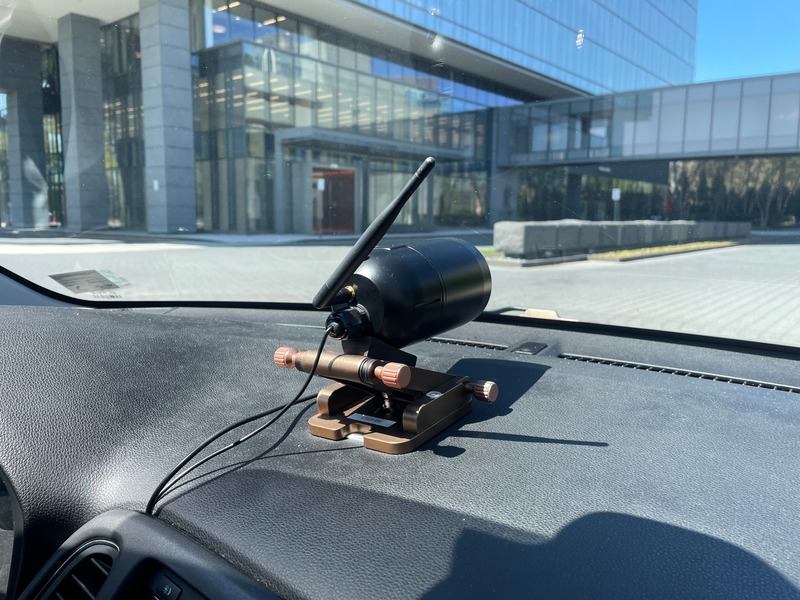
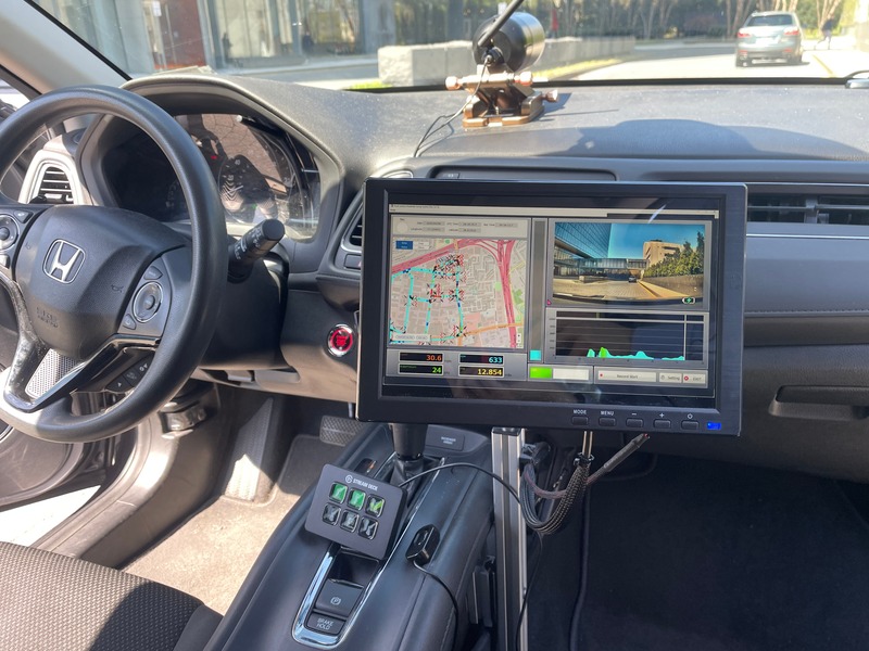
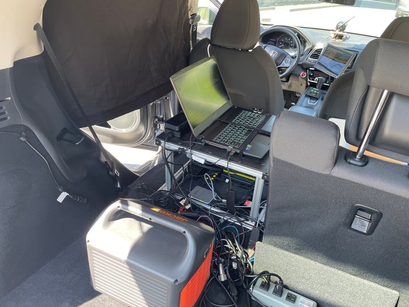
The SRMCV has the added features of a high-definition front-facing dashboard camera, in-vehicle dashboard for monitoring, a laptop computer and backup generator. The camera allows for geolocated video logging and snapshots that are integrated with the pavement condition scanning. Visual imaging is used for video verification of pavement distress and can also be used for visual inspection of other roadside furniture while the snapshots are used for documenting and geolocating points of interest. The system is simple to use and requires no specialized training to operate.
In-Vehicle Equipment
The SRMCV has the added features of a high-definition front-facing dashboard camera, in-vehicle dashboard for monitoring, a laptop computer and backup generator. The camera allows for geolocated video logging and snapshots that are integrated with the pavement condition scanning. Visual imaging is used for video verification of pavement distress and can also be used for visual inspection of other roadside furniture while the snapshots are used for documenting and geolocating points of interest. The system is simple to use and requires no specialized training to operate.
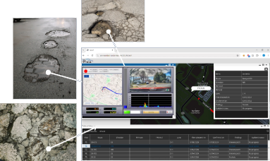
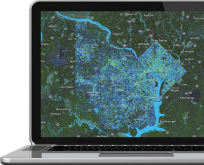
Mapping Outputs
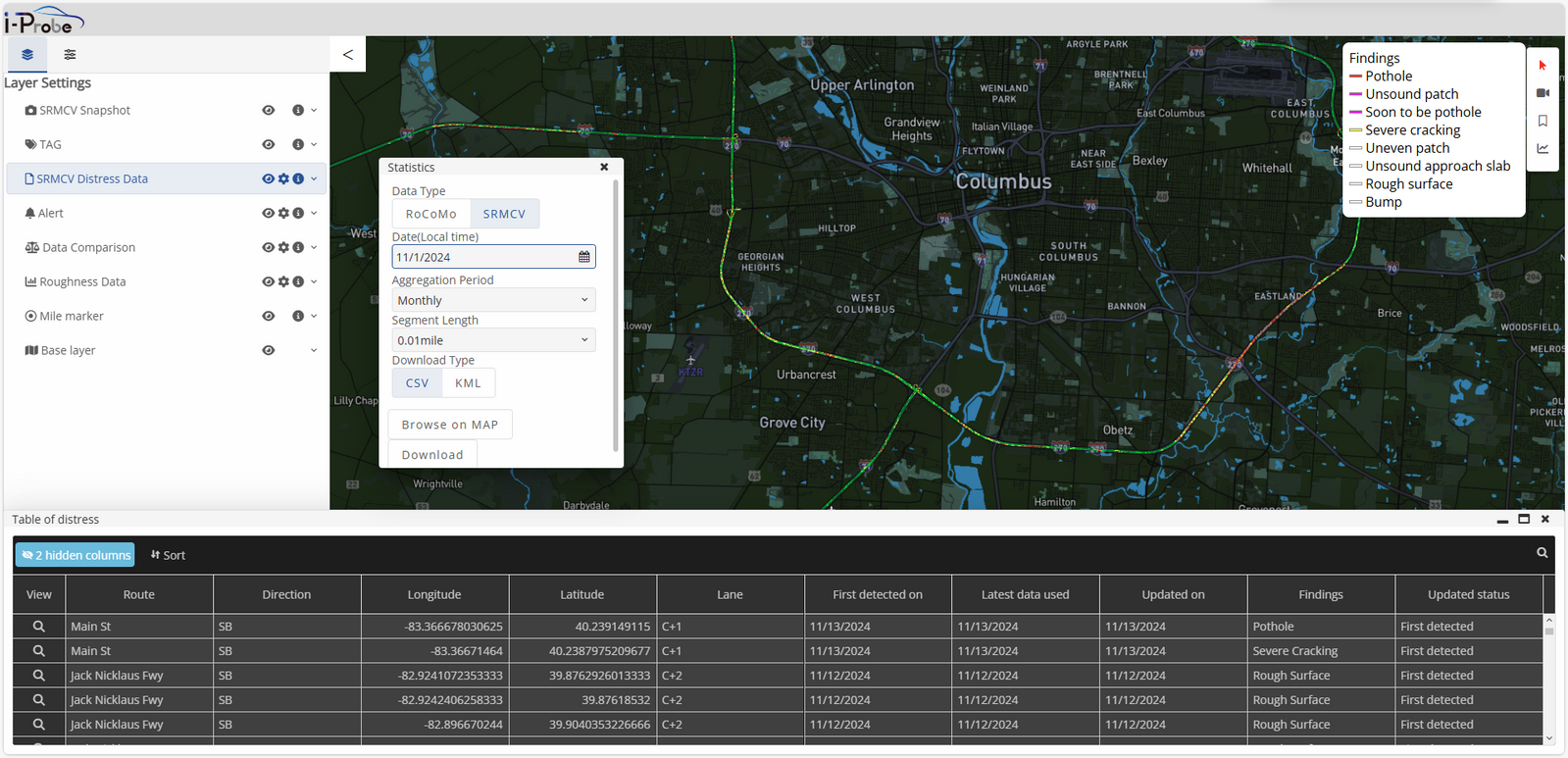
Road roughness mapping with automated tabulation of pavement distresses and related insights.
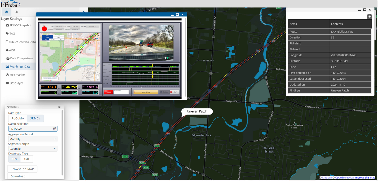
Click any road segment to display pavement distress categorization, insights, and video verification.
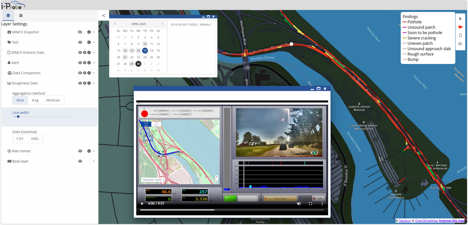
Video playback function to view video logs of any selected road segment at any time.
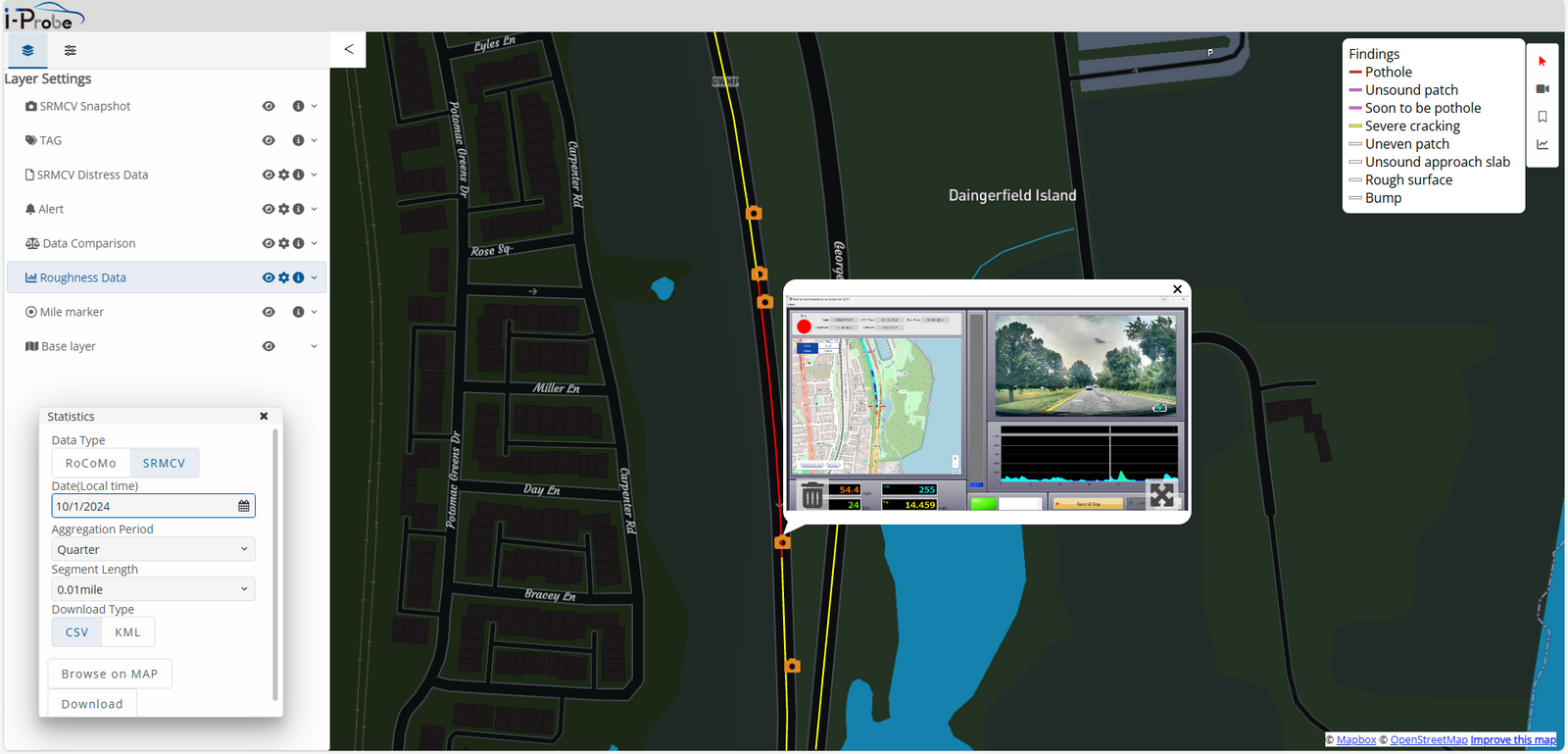
Image snapshot function with geolocation allows for 1-click documentation and automated mapping of key points while driving.
Mapping Outputs
Road roughness mapping with automated tabulation of pavement distresses and related insights.
Click any road segment to display pavement distress categorization, insights, and video verification.
Video playback function to view video logs of any selected road segment at any time.
Image snapshot function with geolocation allows for 1-click documentation and automated mapping of key points while driving.