Road Condition Monitoring Big Data Analytics Service
i-Probe's Road Condition Monitoring Big Data Analytics Service (RoCoMo-BDAS) provides a simple, convenient means of monitoring the road network of an entire city, county or even state, passively and continuously.
How it works
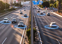
RoCoMo-BDAS is powered by hundreds of thousands of CVs already passively collecting data across the US through i-Probe's strategic OEM partnership.
RoCoMo-BDAS crowdsources data from late-model production vehicles (also Connected Vehicles) driven by regular road users. These CVs transmit onboard sensor data to the OEM (with owner's opt-in at the time of purchase). Data includes driving data (e.g., steering wheel control), movement data (e.g., geolocation), or vehicle condition (e.g., tire pressure). The data from these onboard sensors can also be used to detect conditions of the surrounding environment.
The onboard accelerometer measures the horizontal and vertical movement as a car encounters bumps or drives over rough roads. By combining this road roughness data (ride quality) with geolocation and speed, it becomes possible to effectively map roughness anywhere the vehicle travels. When this data is collected and aggregated from multiple Connected Vehicles in an area, it becomes a powerful tool for mapping the condition of entire road corridors and networks.

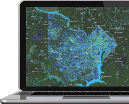
i-Probe can deliver to you road condition mapping of entire cities, counties, or even states - continuously and passively without deploying inspection resources.
i-Probe can deliver to you road condition mapping of entire cities, counties, or even states - continuously and passively without deploying inspection resources.
Work Process
1
Data Collection
2
Analysis
3
Mapping
RoCoMo BDAS
Continuous data collection through fleet crowdsourcing.
Automated pavement distress identification and classification with video verification.
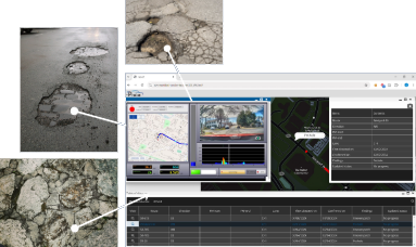
Delivers custom pavement condition mapping with superior turnaround time.
Privacy & Data Protection
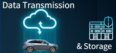
i-Probe fully respects all laws and regulations related to Privacy and Data Protection. i-Probe only uses aggregate and anonymized data in its operations. There is no sharing or selling of personally identifiable information. i-Probe technology only captures data related to road conditions. i-Probe systems utilize robust UTM security and AWS cloud systems.

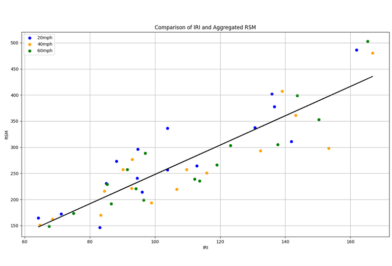
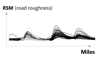
Correlation with IRI
i-Probe systems measure road roughness with an index called Road Surface Monitoring (RSM). In controlled experiments, i-Probe's RSM has been found to be directly correlated with the more common International Road Index (IRI) by a coefficient of 88%. Automated output in IRI is currently under development.
Privacy & Data Protection
i-Probe fully respects all laws and regulations related to Privacy and Data Protection. i-Probe only uses aggregate and anonymized data in its operations. There is no sharing or selling of personally identifiable information. i-Probe technology only captures data related to road conditions. i-Probe systems utilize robust UTM security and AWS cloud systems.
Correlation with IRI
i-Probe systems measure road roughness with an index called Road Surface Monitoring (RSM). In controlled experiments, i-Probe's RSM has been found to be directly correlated with the more common International Road Index (IRI) by a coefficient of 88%. Automated output in IRI is currently under development.
Rocomo - bdas Benefit

Continuous Scanning
With RoCoMo-BDAS, regular road users become your inspection team. Road data collection continues 24/7, 365 days a year under any weather conditions so long as there are regular road users driving connected vehicles.

Robust data security and privacy
All data collected and transmitted from connected vehicles are protected by UTM security and stored in AWS cloud systems. Identifiable user data undergoes anonymization.

Wide area coverage
RoCoMo-BDAS lets you capture data from a single corridor to entire regions in an instant. Specify a time period of data capture for more accurate readings or to compare historic data trends.

Consistent and reliable data
RoCoMo-BDAS machine-based detection and algorithms eliminate human subjectivity and error, improving data integrity. RoCoMo-BDAS enables you to gain insight through trends in consistent datasets.

Save time, Save money
Let road users do the inspections for you every day. Reduce costs with corrective and preventive road maintenance powered by continuous road condition monitoring.

Flexible and customizable output
Customizable applications for mapping, database, and reporting. Multi-format exporting of data. To an extent, integration compatibility with various pavement management systems.
Rocomo - bdas Benefit
Continuous Scanning
With RoCoMo-BDAS, regular road users become your inspection team. Road data collection continues 24/7, 365 days a year under any weather conditions so long as there are regular road users driving connected vehicles.
Robust data security and privacy
All data collected and transmitted from connected vehicles are protected by UTM security and stored in AWS cloud systems. Identifiable user data undergoes anonymization.
Wide area coverage
RoCoMo-BDAS lets you capture data from a single corridor to entire regions in an instant. Specify a time period of data capture for more accurate readings or to compare historic data trends
Consistent and reliable data
RoCoMo-BDAS machine-based detection and algorithms eliminate human subjectivity and error, improving data integrity. RoCoMo-BDAS enables you to gain insight through trends in consistent datasets.
Save time, Save money
Let road users do the inspections for you every day. Reduce costs with corrective and preventive road maintenance powered by continuous road condition monitoring.
Flexible and customizable output
Customizable applications for mapping, database, and reporting. Multi-format exporting of data. To an extent, integration compatibility with various pavement management systems.
Uses
Continuous Historical Data
One additional benefit of data crowdsourcing is that the information is being continuously recorded and stored. Over time, this saved information translates into unbroken historical road data.
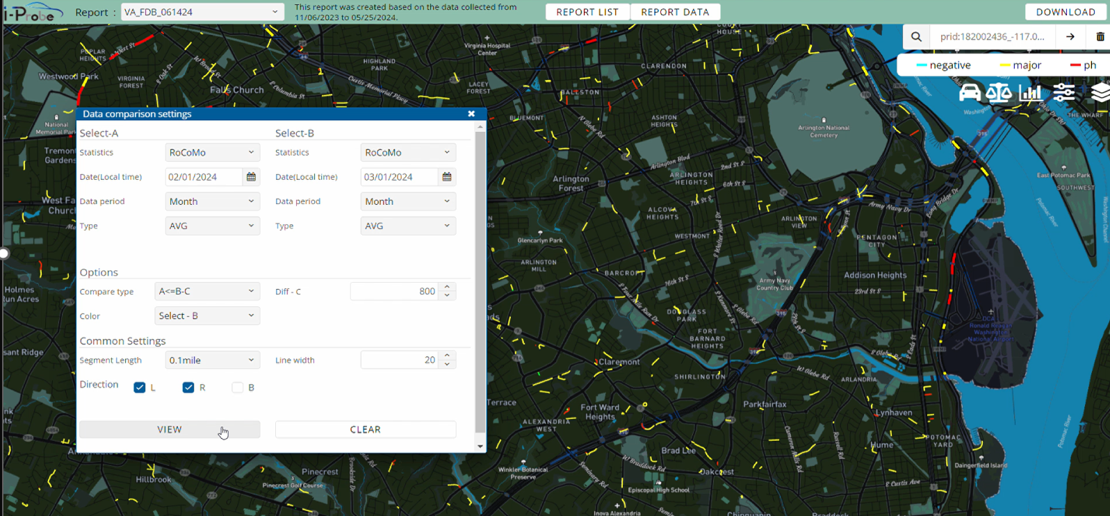
Contrasting datasets of two time periods to isolate changes in road condition.
Uses
Continuous Historical Data
One additional benefit of data crowdsourcing is that the information is being continuously recorded and stored. Over time, this saved information translates into unbroken historical road data.
Contrasting datasets of two time periods to isolate changes in road condition.
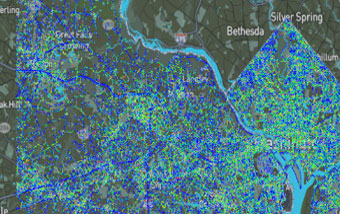
Mapping Outputs
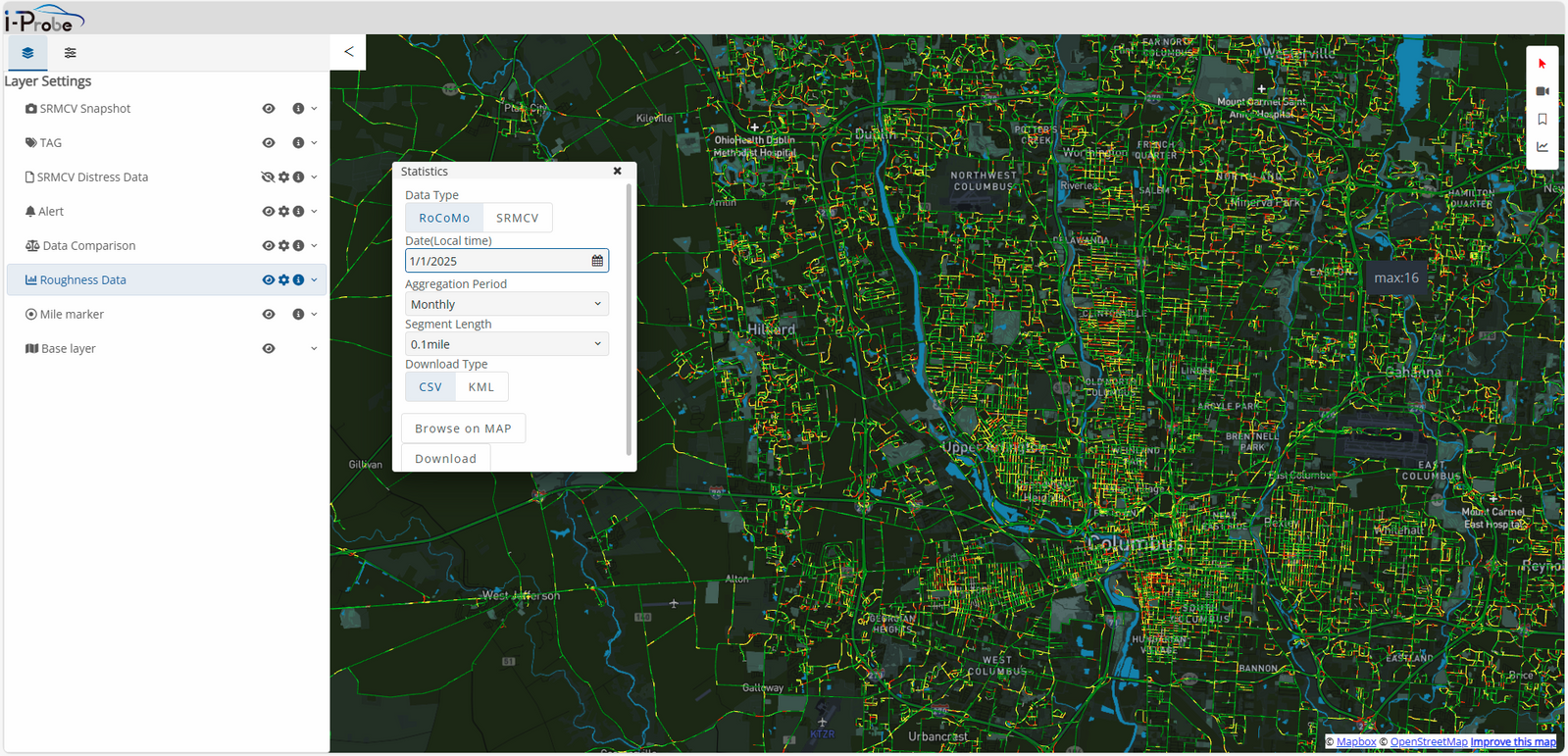
Wide-area mapping of road roughness data displayed as 1-month aggregate.
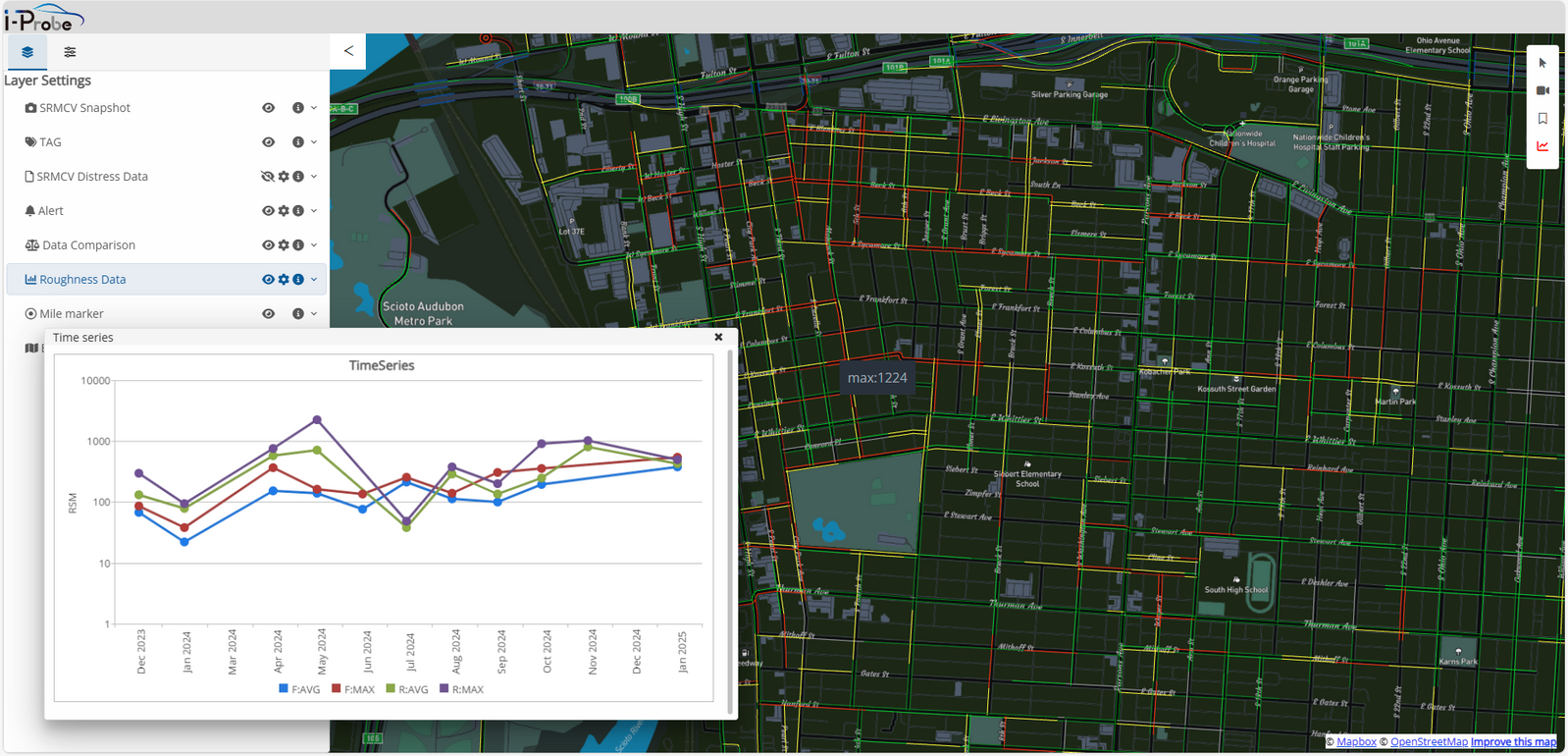
Graphical representation of change in road roughness over time for a selected road section.
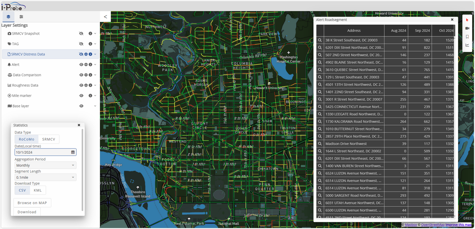
Built-in alert function for the top 100 road sections with largest increase in road roughness over a specified period.
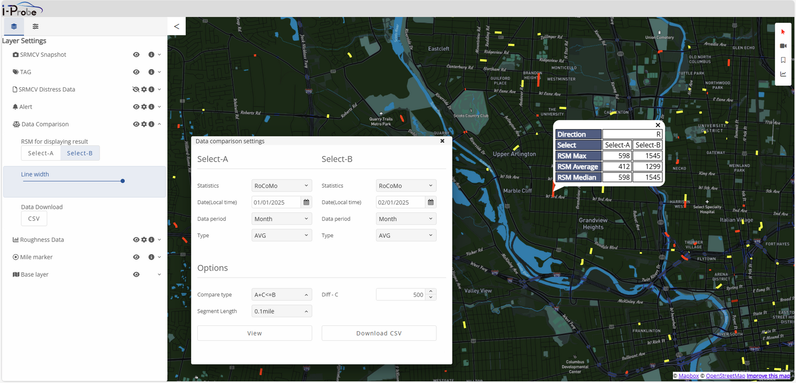
Analytical function to compare road roughness data sets from two different time periods.
Mapping Outputs
Wide-area mapping of road roughness data displayed as 1-month aggregate.
Graphical representation of change in road roughness over time for a selected road section.
Built-in alert function for the top 100 road sections with largest increase in road roughness over a specified period.
Analytical function to compare road roughness data sets from two different time periods.